If you thought political boundaries were the only thing shifting in our world, take a look at this — a map projection that’s got geologists, educators, and curious minds buzzing. Because in the grand scheme of Earth’s history, the borders we know today are just temporary sketches on a constantly moving canvas.
A Glimpse Into the Distant Future of Our Continents
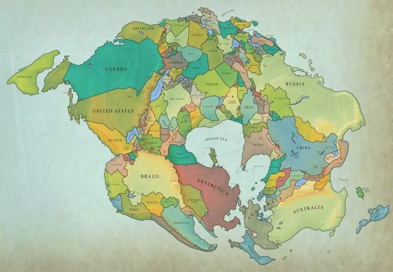
Imagine hitting the fast-forward button by 250 million years. Instead of catching your breath in customs lines, you could drive from South Africa to Mexico in a day. That’s not science fiction — it’s plate tectonics.
Thanks to groundbreaking research from geoscientist Chris Scotese, we now have a fascinating forecast of Earth’s next big transformation: the formation of a supercontinent scientists are calling “New Pangaea.” This isn’t just a bold theory — it’s based on decades of geological data showing how the Earth’s crust slowly shifts due to the movement of tectonic plates.
In the same way all landmasses were once connected as Pangaea some 200 million years ago, the continents are on track to reunite again. And yes, this time Spain might end up with more neighbors than it bargained for.
Europe Merges with Africa and the Middle East
One of the most striking changes? Europe and Africa are set to collide. Countries like Spain, France, and Portugal will find themselves connected to Tunisia, Algeria, and Morocco. Meanwhile, Italy — which already appears to drift closer to Africa — will become part of the same massive landmass.
It’s a dramatic reimagining of familiar geography. The United Kingdom, often proud of its island status, will no longer be separated by the English Channel. Instead, it may sit cheek-to-cheek with mainland Europe — no ferry required.
When the Americas Meet Africa
In the future New Pangaea, North and South America will also join forces with Africa. Picture Georgia and Florida crashing into Namibia and South Africa, forming an entirely new mountainous region — one that could rival the Himalayas of today.
This potential mountain range could even become the highest point on Earth, reshaping not only global maps but also the climate, ecosystems, and migration of life forms across the planet.
What Happens to the Islands?
For island nations, the future is mixed. Australia, for instance, won’t remain a lone continent. It’s predicted to merge with Southeast Asia. Meanwhile, Japan, Taiwan, and South Korea are set to become landlocked parts of a newly expanded East Asian block.
Curiously, only a few territories like New Zealand and Scotland might stay geographically isolated — potentially becoming Earth’s last true island sanctuaries in this supercontinent configuration.
Our Changing Planet, Seen Through Time
While these shifts happen far beyond any of our lifetimes, visualizing them reminds us just how dynamic our planet really is. Plate tectonics, first described in modern theory only in the 20th century, are responsible for everything from volcanic eruptions and earthquakes to the layout of continents themselves.
And maps like these — inspired by research but brought to life by creative minds — offer a humbling perspective. The world we see today is not permanent. Coastlines fade, continents drift, and even the tallest peaks crumble in the face of time.
Final Thoughts: Earth, Always in Motion
So, next time you’re looking at a map, consider it a snapshot of a moment in deep time. The Earth has been here for over 4.5 billion years, and it’s constantly reinventing itself.
And if humans are still around in 250 million years? Well, they might be able to road trip from Madrid to Casablanca without crossing water — or take the scenic route from Texas to Cape Town in a matter of hours.
Because in the end, the world isn’t shrinking — it’s reassembling.